The international miner found planned and unexpected advantages in being able to track the mine environment and assets from a distance.
Progressive mining companies today put safety, automation and data harvesting at the front and centre of everything they do, building in principles from the first plan to mine closure. Doing so often involves maintaining physical distance between people and the dangers of mine sites while at the same time improving the intelligence assets of the organisation to feed smarter decision-making. A case in point is Freeport-McMoRan (FCX) a copper, gold and molybdenum miner, where safety performance and related factors such as effects on local communities and management of the environment are all high on the agenda.
The Phoenix, Arizona-headquartered organisation has global operations and a public commitment to zero catastrophic failures and unplanned discharges from its tailings storage facilities (TSFs). Making use of modern technologies such as satellite imaging and sensor networks helps FCX reach those targets.
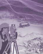
TSFs are hard to miss and, arguably, they are the most public-facing aspects of mining operations. FCX's Tailings, Crushed Leach and Water team work to manage its processes remotely as far as possible. Water resource engineers, geotechnical experts, geospatial scientists, metallurgists, geophysicists and data scientists collaborate to get the most from public and commercial remote sensing data sets. By tapping data contained in Sentinel-2, Landsat, UAS and other sets, FCX accesses the power of optical imagery at high spatial resolutions. This results in high-quality maps that are frequently updated, allowing operators to gain valuable data insights without the expense and difficulty of being on-site.
Transforming Mine Inspections With Remote Control
The remote-control option became essential during COVID lockdowns when it was impossible to make the usual physical mine site inspections. The answer to this for FCX was an extra layer of satellite monitoring. And, once deployed, it saw expected but also unforeseen advantages from greater onsite worker safety to water model calibration.
By adding PlanetScope's constellation of small, lightweight "cubes ats" that monitor most of our world on an ongoing basis to the existing pipeline for Sentinel-2, more timely and extensive observations could be made.
"We leveraged near-daily Planet imagery to map water in our facility and build online maps and dashboards so that operations and crew could adapt their processes," says Leland Sutter, geospatial analyst at FCX.
This unique selling proposition for remote imaging in mining is twofold: it removes people from repetitive and often dangerous tasks, while simultaneously increasing the overall intelligence of the organisation. For example, before partnering with Planet, FCX would physically measure water using markers and range finders. But by using remote imaging with multispectral analysis and applying machine learning models, accuracy and timeliness are massively increased. What was once a quarterly activity is now becoming nigh continuous with data hauled back on a near daily basis.
Enhancing Transparency and Efficiency in Mining Operations
Providing readily available images of ponds and infrastructures promotes transparency since it simplifies imagery sharing to inform upstream and downstream changes across teams and specialists. Detailed tracking can also be applied to ancillary information such as locations of barges, beach width and deposition.
Once deployed, use cases for remote imaging tend to mushroom. While the initial practical application at FCX was for TSF operations and water, it has now become an integral aspect of the company's overall GIS system. Dust control and air quality can be monitored for changes and low-moisture areas targeted forensically for dust suppression.
Other mines say they have also found unexpected advantages in tracking local biodiversity, assessing environmental impacts and sharing findings with local communities.
In an industry that is rapidly becoming abstracted, virtualised and augmented by visual tools, the image is everything. Modern miners are on track to protect their people, digging deeper into data and understanding their environment and the likely impact of actions in real time.
Interested to learn more about safe and sustainable mining? Read the full story on how Freeport-McMoran leverages Planet data to enhance its operations.
If you prefer to have a conversation on how Planet can support your business goals, the Planet team would love to hear from you.
ABOUT THIS COMPANY
Planet

Planet is the leading provider of global, daily satellite imagery and geospatial solutions. Planet is driven by a mission to image all of Earth’s landmass every day, and make global change visible, accessible and actionable. Founded in 2010 by three NASA scientists, Planet designs, builds, and operates the largest earth observation fleet of satellites, and provides the online software, tools and analytics needed to deliver data to users. Decision-makers in business, government, and within organizations can use Planet's data and machine learning-powered analytics to develop new technologies, drive revenue, power research, and make informed, timely decisions to solve our world's toughest challenges.
To learn more visit www.planet.com and follow us on X (formerly Twitter) at @planet.