


Canary Systems is a provider of information systems that help to facilitate a better understanding of risk factors and short and long-term project performance.
With MLSuite 2024, the company has brought to the market a powerful integrated platform for collecting, managing, processing, presenting and analysing vast swathes of monitoring data. By doing so, it has created more favourable conditions for monitoring tailings storage facilities (TSFs) in compliance with GISTM standards.
Integration at the core
The company's work with clients across the mining industry is a living showcase for its commitment to integration, and this is especially evident in the realm of tailings management. Here, Canary Systems' efforts provide for enhanced capabilities and exceptional performance.
Integration constitutes a core principle for Canary Systems and underpins every aspect of its operations, extending far beyond the mere set-up and configuration of instruments to encompass the entire lifecycle of a project. This has the US-headquartered company as an active partner all the way from the initial design phase right through to final reporting and beyond, which provides for exceptional performance and enhanced tailings risk management capabilities.
In addition, to MLSuite, Canary Systems works closely with its clients to design, build and install advanced instrumentation systems, for which it additionally provides ongoing service and support. Such end-to-end service provision creates the conditions necessary for the company to deliver on is mission objective to construct and maintain strong relationships with its clients. Success can come in many guises, but each solution offered by Canary Systems meets and exceeds the requirements and unique challenges of geotechnical and hydrological monitoring.
Platform for success
Canary Systems' integration platform significantly enhances mining personnel's ability to derive meaningful value from their data in several ways.
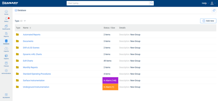
Automated alerts and notifications can, for example, be configured to notify the appropriate personnel of any critical changes or thresholds being met or exceeded. This feature amounts to an invaluable, proactive tool for detecting potential failures early and being able to informatively react to a situation.
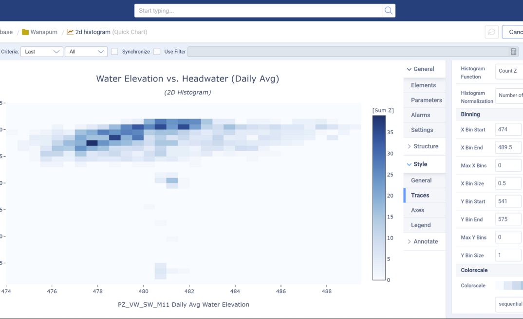
In addition, the web-based platform not only ingests data from more than 50 types of sensors and other sources, but it also unifies it into a comprehensive viewable format. Between advanced charting and three dimensional, georeferenced scenes, MLSuite makes for straightforward ongoing analysis of multiple instruments and effective correlation of the salient information.
Meanwhile, reports can be generated automatically from the platform, ensuring that all necessary data is documented accurately, consistently, comprehensively, and in adherence to prevailing regulatory requirements and internal standards.
GISTM-friendly tech
The Global Industry Standard on Tailings Management (GISTM) has placed greater responsibility on operators of TSFs to ensure their safety across all phases of the lifecycle, including closure and post-closure. To support public accountability, this requires the disclosure of certain information, which is where Canary Systems' MLSuite comes in.
Using processed data accessed on demand, this allows for comparison with baseline data and performance indicators, affording clients the ability to log notes and annotate chart outputs with comments, which can then be saved for future reference.
The platform works to integrate and analyse various geotechnical data types, such as displacement, water content, slope inclination, and vibration, assisting engineers in identifying risks and failure modes. And, with the visualisation and charting tools enabling operators to maximise their instrumentation data and monitoring parameters, this helps to determine the likelihood and nature of potential failures.
With MLSuite, trigger-action-response-plan (TARP) levels can be created by users via the alarm and notification features. This makes possible customisable alarm types and introduces another weapon into the armoury alongside standard and rate-of-change alarms. Furthermore, using MLWebHardware allows devices to be programmed to update data reporting frequencies without requiring programming knowledge.
With GISTM synonymous with customised site-specific solutions, Canary Systems makes automated, scheduled, and customised reports tailored to specific sites readily accessible to Engineers of Record (EoR) and other site personnel. Available at any requested interval, these reports display monitoring results including cross-sectional views, charts, alarm summaries, and the status of sensors and system functionality.
MLSuite 2024 key features
Canary Systems' latest software release, MLSuite 2024 is marked by improvements that serve to elevate and distinguish the platform, giving users a truly transformative experience.
MLWeb, the web-based visualisation component of MLSuite, offers a powerful GIS and 3D engine, and provides users with spatial data capabilities. In addition, the charting engine has been completely re-imagined to offer more interactive options and the ability for users to view data in an integrated fashion. In this way, the flow of information is fully optimised.
Other MLSuite 2024 enhancements include the configuration and display of data for downhole sensors, such as inclinometers and TDR cables. In addition, the process of capturing data changes and setting up specific risk zones for display has been simplified. This means the data classing engine - that which allows for templates defining data patterns, properties, calculations, locations and relationships to be set up – can now create zones in each class for displacement calculations. Furthermore, the streamlining process also introduces the ability to add displacement vectors where necessary.
The platform's enhanced global search functionality additionally helps users to swiftly source and extract any data needed to create a more efficient workflow.
Actionable insights
The process of transitioning from data acquisition to actionable insights is streamlined through the integration component. By consolidating all data into a single platform, the need for multiple systems is eliminated, which facilitates the correlation between different datasets. Such an integrated approach significantly reduces the time required to derive insights from the collected data, while the powerful classing engine enables users to quickly configure data types for best informed operational decisions.
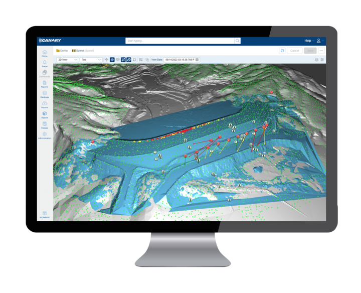
And, with MLSuite offering the option to create 3D scenes with visualisation tools, such as georeferencing, custom instrument icons, vectors, and alarm indicators, this allows for full customisation through opacity, size, and colour setting adjustments to focus on the areas of most concern. In addition, MLSuite provides for navigation from map to detailed data and chart views in a matter of seconds.
A trendline function is further available to enhance monitoring and analysing capabilities, allowing users to visualise trends over time, and identify patterns and anomalies more efficiently. And with trend analysis integrated into the platform, historically collected data allows future trends to be extrapolated from past trends. This increases the ability to provide timely insights, and allows the user to be more proactive than reactive to conditions.